Archive
Project summary download 2020 at Repic
Archives on trial runs and solar installations to be uploaded
![]()
In this video link, student developers Jigar Savla and Viraj Motivaras describe the different components and their functions within the toolkit:
![]() Quicktime
Quicktime

phase#1 konark is a basic gps-gsm DIY toolkit that is self-produced and uses open- source software. Its first objective is to connect a vehicle using gps and gsm to a remote server – thereafter possibilities emerge through a potential range of onboard sensors and through the web and cellular mobiles linking the vehicle to the global information highway.
The basic toolkit may retrofitted onto a vehicle so changing the nature of its interaction with potential users and with the environment of chaotic roadways typical of the megacities like Mumbai.
![]() 2010 toolkit for retrofitting vehicles at D J Sanghvi College of Engineering Mumbai
2010 toolkit for retrofitting vehicles at D J Sanghvi College of Engineering Mumbai
![]()
Contemporary megacities like Mumbai, Lagos and Sao Paulo exponentially multiply and accelerate the processes that put unconnected social actors together; the megacity is the real world mirror of the virtual world’s Moore’s Law whereby computer processing power and scale of information production may double with each year. The megacity is based on the way its inhabitants can interact, the optimisation of communication and movement - more so than its modern physical architecture or its social groupings.
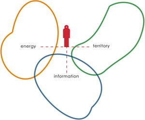
At the heart of it is human mobility.
But the ecology of mobility can not be reduced to energy equations or the carbon footprint of physical mobility.
New social formations require an ecology of mobility with multiple dimensions.
Mobility requires 3 things:
energy, information, and territory.
In themselves each is modeled as self-renewing loops that interconnect and overlap with each other.
![]()
![]()
![]()

A collaboration with Clean Air Island 2008-2018
